Microsoft Research Intern Builds ML System to Forecast Space Weather Risk to Power Grids
A Microsoft Research intern has developed a machine learning system that forecasts space-weather risk for 66,935 substations in the continental United States, giving grid operators a warning of 30 to 60 minutes. According to Microsoft Research, the pipeline detected nearly 80% of major space-weather events during its evaluation period.
- The ML pipeline estimates space-weather risk for 66,935 US substations, 30 to 60 minutes ahead of potential impact.
- It detected 76.5% of major, 81.2% of severe and 64.1% of extreme events in the 2020-2026 evaluation.
- Inference for all substations takes approximately 333 milliseconds, according to Microsoft Research.
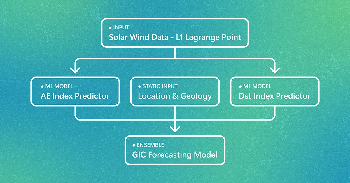
- The system combines AE and Dst forecasts with latitude, geology and ground conductivity.
- Further validation with utilities and operational data is needed before use in grid operations.
A pipeline from solar wind to substation risk
The project was developed by Rohan Kannan during a summer internship at Microsoft Research. It addresses a known threat: extreme space-weather events can induce currents in transmission networks that damage equipment and increase operational risk. The source points to the May 2024 geomagnetic storm, when utilities across North America prepared for possible impacts as auroras extended far beyond their usual range.
The system works in three stages. First, solar-wind measurements from the L1 Lagrange point are used to forecast the Auroral Electrojet (AE) and Disturbance Storm Time (Dst) indices, while geological conductivity and location features are assembled for each substation. Second, a gradient-boosting model combines these inputs to estimate dB/dt, the rate of magnetic-field change associated with risk from geomagnetically induced currents (GICs). Finally, the predictions are converted into location-specific risk estimates and aggregated into a continental risk assessment.
Microsoft Research says a system of 50 AI agents helped explore features, validation strategies and model configurations. Only public data sources were used, including NASA OMNI and NASA-aggregated Kyoto World Data Center data, INTERMAGNET and U.S. Geological Survey magnetometer observations, and GridSFM-derived grid data.
Why location matters
Ground effects depend heavily on local conditions. According to the post, regions with resistive bedrock can experience stronger GICs than regions with more conductive geology, and transmission-line orientation, latitude and other power-system traits also affect the exposure of individual assets.
Instead of issuing one alert for the whole country, the system combines storm conditions with each substation's latitude and geological factor. The result is a continuous risk estimate that can separate lower-risk locations from areas where resistive geology can amplify effects at ground level. Microsoft says the pipeline produced estimates for all 66,935 substations in approximately 333 milliseconds during measured inference, so many scenarios can be evaluated quickly.
The continental map shown in the post is a demonstration of a representative major-storm scenario, not a record of a live operational event.
Evaluation results
The evaluation covered 2020 to 2026. For the AE predictor, the post reports a 410.2 nT RMSE, lower than empirical and solar-wind-only baselines, with forecasts spanning nearly the full observed range of AE activity. The Dst predictor reached a 7.2 nT RMSE and outperformed the Burton equation on 62.2% of individual hours during the most geomagnetically active periods. Combined with AE forecasts, it improved severe-event detection in the end-to-end system by 1.2 percentage points.
For the GIC risk stage, there is no widely deployed operational system to serve as a direct industry benchmark, so the model was compared with simple linear regression. Detection rates were:
- 76.5% for major events (at or above 10 nT/min)
- 81.2% for severe events (at or above 20 nT/min)
- 64.1% for extreme events (at or above 50 nT/min)
False-alarm rates rose with storm severity, which the post describes as a trade-off between missed events and cautious alerts. Detection was strongest at northern stations, where geomagnetic activity is highest.
What it could mean for utilities
Microsoft Research suggests that earlier, location-specific information could help utilities prioritize engineering review and consider targeted protective actions, such as adjusting reactive-power reserves or temporarily reconfiguring parts of the network. It stresses that further validation with utilities and operational data would be needed before the system could be used in grid operations.
Planned next steps include extending forecast horizons beyond the current 30 to 60 minutes with temporal-transformer approaches, adapting the system to other regions and grid topologies, integrating forecasts with existing decision-making workflows, and moving from substation-level to transformer-level risk estimates. The work also ties into Microsoft Research efforts on AI for power systems, including GridSFM, which applies deep learning to AC optimal power flow for fast scenario analysis.
Microsoft Research: Forecasting space weather risks on power grids