Ai2 releases PLANTEUR, a crop-mapping benchmark for tropical farmland
Ai2 has released PLANTEUR, a benchmark that extends the PASTIS crop-type mapping dataset from metropolitan France to six tropical regions. According to Ai2, every method it evaluated scores substantially lower on the new benchmark than on PASTIS.
- Ai2 released PLANTEUR, an extension of the PASTIS crop-mapping benchmark to six French overseas territories in the tropics.
- The dataset has 2,750 aligned Sentinel-2, Sentinel-1 and Landsat-8 time series and 4,506 km² of parcel-derived labels across seven crop classes.
- According to Ai2, every evaluated method scores substantially lower on PLANTEUR than on PASTIS.
- Models lose roughly half their accuracy on an island not seen in training, Ai2 says.
- PLANTEUR is available on Hugging Face and GitHub.
What PLANTEUR covers
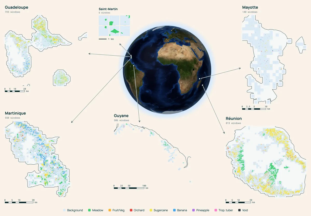
PLANTEUR spans six French overseas territories across the Caribbean, South America and the Indian Ocean: Réunion, Guadeloupe, Martinique, Guyane, Mayotte and Saint-Martin. Ai2 built it from the same data source as PASTIS, France's Land Parcel Identification System.
The format closely resembles that of PASTIS, which is meant to make it easy to plug into existing evaluation pipelines. According to Ai2, the dataset contains:
- 2,750 aligned Sentinel-2, Sentinel-1 and Landsat-8 time series
- 4,506 km² of parcel-derived labels
- seven crop classes, including sugarcane, banana, pineapple and tropical tubers, a group that covers root crops such as cassava, yam and taro
Why a tropical benchmark
Ai2 notes that foundation models and open data are driving rapid progress in machine learning for remote sensing, and that benchmarks help show how much models actually improve. PASTIS is described as one of the community's most trusted benchmarks because of its high-quality labels and geospatial metadata. Its coverage, however, is limited to metropolitan France.
Crop-type mapping is the starting point for food security planning, water allocation and tracking how farmland changes, according to Ai2. The organization says it wants teams building geospatial foundation models to be able to check whether their models work in agricultural systems where mapping could be most valuable: smallholder, tropical and topographically complex.
Baselines and early results
Ai2 includes baseline numbers for several linear probes and supervised methods. They are reported across several setups: a standard split, a leave-one-island-out split, a few-shot setup, and one that adds PASTIS samples to the training data.
According to Ai2, these baselines introduce new challenges: performing well in the tropics, generalizing to unseen regions, learning from scarce labels, and transferring knowledge across agricultural systems.
The results show a clear gap. Ai2 says every method it evaluated, its own included, scores substantially lower on PLANTEUR than on PASTIS. It also reports that every model loses roughly half its accuracy when tested on an island it never saw in training.
What it means for model builders
The benchmark gives developers of remote sensing models a way to test crop-type mapping across many more geographies than before. Ai2 says it hopes PLANTEUR will do for tropical contexts what PASTIS did for metropolitan France, motivating the community to develop strong methods for them.
The size of the drop on unseen islands suggests that current approaches have a long way to go before they transfer reliably between tropical regions. PLANTEUR is available on Hugging Face and GitHub, and Ai2 also links a tech report with the release.
Ai2: A crop-mapping benchmark for the tropics